Jenna’s Project Review

When I first heard about Jenna’s project idea I thought it was such an awesome concept. Battle Bites! a convenient and interesting way to present historical information to the public. She made two videos surrounding the Battle of Hastings, 1066.

I’m very impressed with the way to videos turned out. From the in-class presentation she was having a hard time with the production end of things, along with some decisions on how she wanted the video to look. I think the video works for the her younger target audience to present the information in a fun and interactive way. It even works for an older audience because it gets the most important information across without it being wordy.

Without further ado, I present Jenna’s  Battle Bites:

part 1 – http://www.youtube.com/watch?v=EcZYdl6HPe4

part 2 – http://www.youtube.com/watch?v=8tJ6WwasR10

Also, if you like her videos, follow her twitter account @BattleBites to get notifications about upcoming videos!
 

Final Project

So first I should apologize for the lack of content on the blog…I was bus working on the final project (as well as some other project for other classes). A reminder: my project was an online exhibit about the Scottish chapbooks in the Archival and Special Collection, University of Guelph Library. My section is on heroism; using the chapbooks as a tool to define the qualities of a hero and the difference between heros represented in the chapbooks and the superheroes in the comic books. IN a way this project is a comment on the change in literature and difference between them within the same theme. I wanted to have more than one heroic figure to include in the exploration but from the chapbooks I picked out, not all of them gave me the information I needed. The conclusion of the project: the qualities and definition of a hero is timeless throughout the changing style of literature.


You can look at the finished product at (my section = HEROISM: http://melissamcafee.omeka.net/exhibits/show/scotish-chapbooks

I hope the link works!

Quick Monday morning update…

Hey,

So I’ve been meeting with my group members and Melissa to go over what she wants from us as far as layout and scanning procedures; seems pretty easy. I have no problem on the whole exhibit design front, I’ve done some in the past and am doing one in tandem. What I’m worried about is if my topic is interesting enough or will give me enough to work with and some insight into the chapbooks; or if it will be just another half thought out idea. I have briefly lookd at some of the chapbooks related to my topic and they seem more like formal stories instead of informal rants by an author (what I hoped they would be).  I might have to tweak my thesis when I’m searching. Ughh!

I did mention in my class presentation that I could look at English chapbooks in comparison but I don’t know if that’s even possible or if it would take to much attention off the Libraries collection. 

Decisions, decisions … and they better be fast my time to work on them is dwindling!

Project Update…

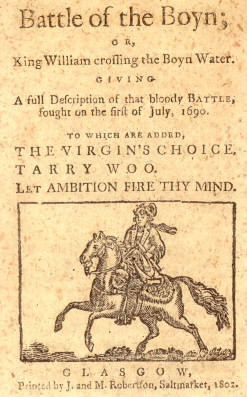
My last post was a cover shot of a Scottish chapbook, a prelude to my course project topic. I have mentioned the possibility of doing something with GIS, however, jumped at the opportunity at helping the universities library digitizing their large collection of chapbooks.  FYI: the University of Guelph Library has one of the largest Scottish collections outside the UK, amazing! So instead of the rest of my brave classmates, I chose the chapbooks.

Firstly, I just went through the list of titles to see if any caught my interest for a topic. I had thought of tracking one story throughout the years. I saw the story of “Duke of Gordon’s three daughter’s” as an example.  There’s a edition in 1820, 1824, 1850 and finally one in 1850.  Why so many publications throughout the years, why those years? Was it that popular to keep publishing it, if so, what was its appeal?

I then saw a lot of battles portrayed in the chapbooks, Battle of the Boyne being one of them, but others that I have never heard of. This coming from a history nerd and a special eye on the British Isles. What were these battles about and what was their significance then and now? Who were the key figure’s, what were their motivations. If I hadn’t heard of them then do they, if at all, change my understanding of Scottish history?

After tossing about a few more ideas about looking at biographies and religious content I had found my topic: Scottish heroes vs. villains!  I’m going to look at the chapbooks as a tool used to depict the heroes and the villains of the time.  I can incorporate biographies, battle accounts and folk tales as a base to work off of; for example the biography of William Wallace as popular Scottish hero and patriot.

Stay tuned for other updates and names of some people I find in my search!

Its APP time: Romeo and Juliet style!

Canadian Adaptations of Shakespeare Project (CASP) is a research project devoted to all things William Shakespeare. Its a database developed by University of Guelph Professor Daniel Fischlin.  The database allows full access to Canadian adaptations and productions of Shakespeare’s plays. The second version launched in 2007 offered teaching and multimedia resources for its audience. CASP has an ongoing commitment to blending humanities research, new media, online publishing, accessibility, and community engagement.

Admirable qualities, right?! But, here’s the cool part, CASP has ‘an App for that‘. The Romeo and Juliet App is interactive and a useful study guide!

As you can see by the website, the app gives an in depth look into the story, characters, plot and gives you fun facts, and sources referenced in the play and for your own research. Its a great way to incorporate information and learning into popular culture. Romeo and Juliet is one of the most popular plays Shakespeare has written and is studied widely. I highly recommend this app if your interested in brushing up on the Shakespeare epic love story.

Digital Haptic Lab

I had heard about 3D printing when it first became popular to the public and I remember myself thinking … how cool is that to print images into a 3D object. One of my friends even said, jokingly, “what if they could print food in a few years with this stuff.” Umm, yah they actually said that. Looking back on the comment its hilarious but, that’s besides the point. You can only imagine my surprise when i found out the University of Guelph has its own Digital Haptic Lab. The website gives background information on the men behind the scene’s and some of their projects (the possibilities seem endless). Last week I had the pleasure of visiting the Haptic lab myself. I got to test some of the tools they use so, I had to share this with you all.

Enjoy and let your imagination run wild!

Did you ask for more GIS?

Two things on the agenda:

1. Found another awesome GIS website that I had to share. Its so cool as a historical stand point but also as a “just looking at stuff” point too. Who doesn’t want to see how really old buildings looked like? Go and transport yourself to far off lands and distant times!

2. Continuing my GIS theme… not going to lie I might be in love with it! The range of topics/themes and uses you can manipulate with some GIS data is fantastic. I’m kinda of going of what I said last post about using the Agas maps and comparing them to other maps to get an understanding of what changed in the city and possibly give an explanation of why.  I’m not sure how accessible those maps would be to someone across the ocean, so I might have to narrow my search to somewhere in Ontario around Guelph.  I know cities will have town records and such. Oh, perhaps I could apply this to the university itself? The University Archives has tonnes of stuff to the original land receipts, postcards of the “Experimental Farm” and land survey’s of when the farm expanded into the OAC; that I know for sure. So I would get images, survey’s and ariel photos of the university and area over the years to what….for what purpose? Is saying “to illuminate the early years of the development of the University of Guelph” a good enough purpose. To make it into an available set of information for the campus students and community. I could create a fun video like this.

I’m not sure if my idea for the project is any good. Got any suggestions?


GIS [T] listen,

Image
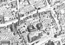
For those of you who don’t know Ralph Agas, this is part of his map of London.  He was an English land surveyor who published several city maps in the 1590s.  Now cartography has come a long way since the sixteenth century but scholars are using his maps in their work today, so it must be good enough for them.
The work I’m talking about is The Map of Early Modern London (MoEML). The MoEML team has basically digitized the old Agas map of London and plotted different streets, areas, buildings and historical attractions throughout the city.  Its purpose? A sixteenth-century historical interactive map.  Now I’m sure you have all heard of or used Google Maps/ Earth.  You’ve all played around with the program and  zoomed in on an ariel view of your house or a different city or even a landmark.  Essentially MoEML serve’s this purpose for London in the 1500s (except for that whole satellite, zoom-in capability).  The map is useful not only for random curiosity but, also for academic reasons.  Not many scholars have access to Agas’ maps so the fact that its available on the internet is a bonus.  Maps back then were rarely labelled like we use them now, street names and such.  The interactive capability is fascinating because you are able to fully understand the map and not guess the where-about’s.  Like Janelle (team leader) says in the “About” section; she got the idea because she was using the map to show her students the, “the geographical relationship between the city and Renaissance theatres, to map out the routes of processions and pageants, and to show how the Lord Chamberlain’s Men (later the King’s Men) moved their business operations from the Theatre in the north, to the Globe on the Bankside on the south side of the Thames, to the Blackfriars complex in the heart of the City of London.”
I think its fascinating to be able to look on a map and envision the city of London some 420 years ago.  It would be a cool project to compare Agas’ maps to current maps of the cities and determine the areas on change from industrialization and modernity and which areas stayed relatively the same and why… a possible final project idea perhaps.
Here is a list of other people known for their map making.

The Orlando in Orlando and Rosaline?

That’s what I thought about when the question, “Why the name, who is Orlando?’‘ was asked in class the other day. Rosaline’s love interest in As You Like It; not Orlando Bloom but the other famous one. (You can learn about it on the website)

Today’s blog is about the ORLANDO Project.  Its an amazingly vast and ongoing database about British women authors (another example of one of those digital tools).  One of the unique things about this database is the ability to see the Markup of any search result (found in the top right corner).  It essentially shows you the computers design layout of that particular page. I hope some of you will appreciate this function, I know I do…its interesting to see a different way to look at the information presented!

Give it a look, even learn about your favorite female author!