Did you ask for more GIS?

Two things on the agenda:

1. Found another awesome GIS website that I had to share. Its so cool as a historical stand point but also as a “just looking at stuff” point too. Who doesn’t want to see how really old buildings looked like? Go and transport yourself to far off lands and distant times!

2. Continuing my GIS theme… not going to lie I might be in love with it! The range of topics/themes and uses you can manipulate with some GIS data is fantastic. I’m kinda of going of what I said last post about using the Agas maps and comparing them to other maps to get an understanding of what changed in the city and possibly give an explanation of why.  I’m not sure how accessible those maps would be to someone across the ocean, so I might have to narrow my search to somewhere in Ontario around Guelph.  I know cities will have town records and such. Oh, perhaps I could apply this to the university itself? The University Archives has tonnes of stuff to the original land receipts, postcards of the “Experimental Farm” and land survey’s of when the farm expanded into the OAC; that I know for sure. So I would get images, survey’s and ariel photos of the university and area over the years to what….for what purpose? Is saying “to illuminate the early years of the development of the University of Guelph” a good enough purpose. To make it into an available set of information for the campus students and community. I could create a fun video like this.

I’m not sure if my idea for the project is any good. Got any suggestions?


GIS [T] listen,

Image
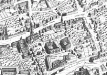
For those of you who don’t know Ralph Agas, this is part of his map of London.  He was an English land surveyor who published several city maps in the 1590s.  Now cartography has come a long way since the sixteenth century but scholars are using his maps in their work today, so it must be good enough for them.
The work I’m talking about is The Map of Early Modern London (MoEML). The MoEML team has basically digitized the old Agas map of London and plotted different streets, areas, buildings and historical attractions throughout the city.  Its purpose? A sixteenth-century historical interactive map.  Now I’m sure you have all heard of or used Google Maps/ Earth.  You’ve all played around with the program and  zoomed in on an ariel view of your house or a different city or even a landmark.  Essentially MoEML serve’s this purpose for London in the 1500s (except for that whole satellite, zoom-in capability).  The map is useful not only for random curiosity but, also for academic reasons.  Not many scholars have access to Agas’ maps so the fact that its available on the internet is a bonus.  Maps back then were rarely labelled like we use them now, street names and such.  The interactive capability is fascinating because you are able to fully understand the map and not guess the where-about’s.  Like Janelle (team leader) says in the “About” section; she got the idea because she was using the map to show her students the, “the geographical relationship between the city and Renaissance theatres, to map out the routes of processions and pageants, and to show how the Lord Chamberlain’s Men (later the King’s Men) moved their business operations from the Theatre in the north, to the Globe on the Bankside on the south side of the Thames, to the Blackfriars complex in the heart of the City of London.”
I think its fascinating to be able to look on a map and envision the city of London some 420 years ago.  It would be a cool project to compare Agas’ maps to current maps of the cities and determine the areas on change from industrialization and modernity and which areas stayed relatively the same and why… a possible final project idea perhaps.
Here is a list of other people known for their map making.

The Orlando in Orlando and Rosaline?

That’s what I thought about when the question, “Why the name, who is Orlando?’‘ was asked in class the other day. Rosaline’s love interest in As You Like It; not Orlando Bloom but the other famous one. (You can learn about it on the website)

Today’s blog is about the ORLANDO Project.  Its an amazingly vast and ongoing database about British women authors (another example of one of those digital tools).  One of the unique things about this database is the ability to see the Markup of any search result (found in the top right corner).  It essentially shows you the computers design layout of that particular page. I hope some of you will appreciate this function, I know I do…its interesting to see a different way to look at the information presented!

Give it a look, even learn about your favorite female author!

Digital Tools, humm lets see…

“How have my studies at Guelph been affected by digital tools and  approaches, and what future possibilities do I see?”
The major digital tool that UoG has to offer us is CourseLink, a website dedicated to the organization of all things academics.  It holds links to each individual course for your current semester.  Within these: links information, notifications from Profs, lecture notes and a reading list is available. Some even have a discussion forum to communicate between the class list an ask questions.  Sounds like a great site! It is a great tool towards my education… I’m not sure what I would do if the university stopped using it tomorrow.  I use it multiple times daily, some might say its the whole grail of digital tools UoG offers, and I agree!
I have also done a few online classes in my educational career.  I few in highschool and the same in university, however, the highschool ones are small in comparison.  Everything about the UoG dis-ed course is run through CourseLink (…did I mention its the holy grail).  I haven’t had any problems with the course’s I have taken; except for the usual, like certain students filling up the discussion board with questions they could have easily found answers to if they looked around the site.  Besides the point.
I think the other major digital tool I have used extensively are online search engines and databases (like Google or Early Canadiana or JSTOR). Endless hours spent on one of those databases with a coffee in my hand to complete one of the many papers due.  Its pretty explanatory how these databases have helped my academics…my grades for one and my critical analysis of those sources, second.
Come to think of it my knowledge and use of digital tools is limited and maybe lacking compared to others, but no one said learning more was a bad thing.
Got any other tools I should look into?

Hi!

Hello to the world of internet,

This post is a little introduction to the person behind the blog, so here we go…

My name is Hailey and I am a farmer’s daughter outside a small town in rural Ontario. I know the feeling of hard work and long hours.  It seems natural that I would move to an agriculture university; except for the fact that I’m a 3rd year history and museum studies student. In a family full of farmers I broke the mold so to speak.

To be honest, I’m not the most tech-savvy person out there.  Like any other person I want the internet to do what I want and when I want it; what more could you ask for? And it has…for the most part so, believe me when I say I never thought of myself starting a blog. Yes the push was for a class but it still feels a little foreign (even in a generation that is dependent on the internet).  I guess I’m antiquarian that way… I like reading news in that old fashioned thing called a newspaper and my notes handwritten on paper not off a computer screen.

The course is about exploring the interdisciplinary topic of digital humanities. So why take a course that makes you do things you never thought?  For exactly that reason! It’s out of my comfort zone. It something new and different to experience, learn and think about.

Want to join in my [un]comfortable exploration…?